Berlin guide from bird's eye view - Horydoly.cz - Outdoor Generation
The storefront of the former West Berlin, the Kurfürstendamm avenue is hidden far behind the Tiergarten park, where you can hardly see it.
However, it does not change the fantastic view from the TV Tower. I just want to warn you about one thing. Don't come here in the evening. I waited for it to get dark and admire the garlands of lights, but it was not worth it.
The puzzle is what time of day to go to the tower. In the morning, the sun will shine westward on all of Berlin's most important buildings. Or in the evening like me and watch the endless East Berlin in the sunset?
We will start the tour in the direction of the west
On the lower left we can see the brick Neo-Renaissance building of the Berlin City Hall, called the Rotes Rathaus. Behind it is the oldest church in Berlin, the Nikolaikirche, built in the 13th century. The Nikolaiviertel district, the historic center of Berlin, has been rebuilt around it. Here stood the first Berlin settlement. The free space on the right is the Marx-Engels Forum. The former Palace of the Republic peeks out behind it.
The famous Unter den Linden avenue, full of palaces and important buildings, is here in the middle of the picture. It is still Karl Liebknecht Strasse until the wide avenue turns to the right. Around the bend, it's Unter den Linden and it goes all the way to the Brandenburg Gate. The huge green area behind it is Berlin's largest park, the Tiergarten. The Love Parade marched through this very park. This is where West Berlin begins. The Tiergarten stretches from the Brandenburg Gate to where West Berlin proper begins with the famous Kurfürstendamm boulevard, colloquially known as Ku'damm. On the upper left we see the skyscrapers on Potsdam Square. Somewhere in the space between Potsdam Square and the Brandenburg Gate was Hitler's New Chancellery and his bunker. The dome of the Reichstag can be seen to the right of the Brandenburg Gate.
Down in the middle we see the demolition of the former socialist Palace of the Republic. The asbestos-ridden structure was loaded onto ships that took it away along the Spree Canal. Honecker's boast was used for party conventions and entertainment shows Ein Kessel Buntes, which was supposed to be a sort of comradely Las Vegas. After its demolition (the photo is two years old), the City Castle, demolished by the communists in 1950, is to be rebuilt here.
Below, on the far right, is the Radisson Hotel and behind it the evangelical Berlin Cathedral with its massive dome. The low building behind him at the bend of the avenue is the German Historical Museum. The Berlin Cathedral actually already lies on the Museum Island, it is surrounded by the river on both sides. Museum because there are famous Berlin museums on it, but here out of the picture on the right.
The two green domes in the middle of the photo are St. Hedwig's Cathedral, the seat of the Archbishop of Berlin. In front of the cathedral is Bebelplatz, the place where the Nazis publicly burned twenty thousand books on May 10, 1933.
The tip of the Mariankirche church can be seen at the bottom of the photo. It is considered to be the second oldest church in Berlin after the Nikolaikirche. Across the river you can see the Museum Island with the famous Pergamon Museum. There are five museums in total. The S-Bahn city train is just crossing the river behind him.
View towards the northeast. Alexandr Platz begins in the lower right corner. Karl Liebknecht Strasse heads up towards the popular Prenzlauer Berg district. Like Kreuzberg, it was once a backwater border district. A thriving place today. Here you will also find the Mauerpark, a park with a piece of the former wall, and a little further on the Berlin Wall Memorial.
Alexanderplatz at the time it was undergoing renovation. On the lower left is the Fountain of Friendship between Nations. Milan Sýkora commented on Horydoly's impression of this socialist building: "It seems terribly confusing to me and I am not able to understand its symbolism. In addition, I am missing something... There is no water in it." In the middle is Karl Marx's classroom, an example of socialist realism. It is two kilometers long with an average width of 90 meters. Anyone who wants to get an idea of the architecture of that time should head here. It was also here that the workers' strike began in June 1953, which turned into a bloody uprising.
East Berlin in its full beauty. Otto-Braun-Strasse goes to Prenzlauer Berg. The tip of the church in the middle is the church of St. Bartholomew on the corner with Friedenstrasse. Wind farms are lost in the haze on the horizon.
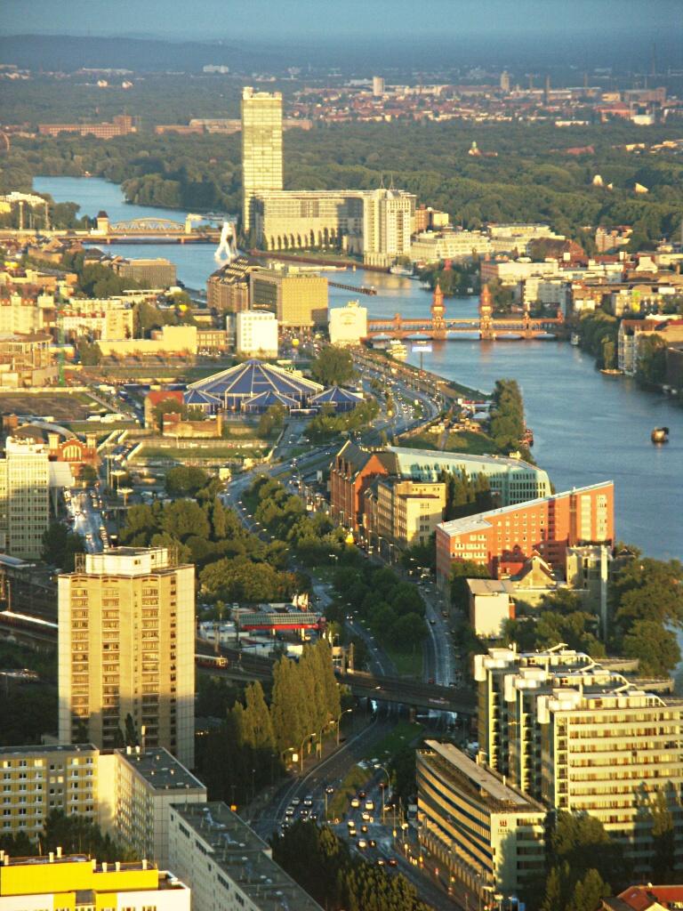
Residential construction. Karl Marx's class on the far left. Back in the middle of the red roofs of Berlin's smallest district, Friedrichshain. A traditional working-class neighborhood with low rents, it is now popular with students and artists. Together with Kreuzberg across the river, they form one administrative unit. You can see the vaults of the Eastern Railway Station at the far right in the middle. Between 1987 and 1998, it was called Hlavní nádraží, and if you traveled to Berlin by train, you arrived here. Today's Hlavní nádraží is located not far from the Reichstag.
It wasn't until looking at the photos that I discovered the existence of the ruins within sight of the TV tower. It is the Klosterkirche, a ruin of a Franciscan monastery. It was built in the middle of the 13th century, and in the 16th century it was rebuilt into a prestigious gymnasium, where the founder of the German state, Otto von Bismarck, also studied. Destroyed at the end of WWII. It now serves as an exhibition and theater space. The Spréva meanders here and forms the border between the former East and West. On the opposite side, close to the river, there is another building that looks like a church with a green roof, but it is the Märkische Museum, the museum of Brandenburg and Berlin. The entire red brick complex was designed as a copy of traditional Brandenburg buildings. The tower is modeled after the bishop's palace in Wittstock. Towards the left, the chimneys of the Heizkraftwerk Mitte thermal power plant rise in the building. The famous techno club Tresor is located in its old part. And in the very bottom right corner you can see a piece of the Rotes Rathaus, Berlin's red brick town hall. The circle is closing.
On the opposite side of the river lies the Kreuzberg district, one of the most famous in Berlin. One of the poorest neighborhoods gradually turned into one of Berlin's cultural centers. It is known for its large Turkish community and the seat of alternative culture.
The double bridge connecting Friedrichshain with Kreuzberg is called Oberbaumbrücke. The bridge from 1896 also appeared in the famous film Lola runs for life. On the Friedrichshain side you will find the East Side Gallery, the longest section of the preserved Berlin Wall. Beyond the bridge, a huge sculpture called the Molecular Man floats on the water. Next to the sculpture is the Treptowers administrative complex. The thirty-story skyscraper Alianz rises to the sky as the tallest office building in Berlin. The large green area behind it is already Treptow Park with a monument to Soviet soldiers.
Booking.com
Berlin on HORYDOLY
A guide to Berlin from a bird's eye view
Colossus of the Nazi Empire (Haus der Ministerien)
Potsdamer Platz (Postupim square)
We happily demolished a wall of concrete and steel
The Berlin Wall has been gone for 30 years
A trip to socialist Berlin
Dome over Berlin
Retro is in vogue
One moment in Germany
Show the place Turistika on a larger map


